


Chris Fawkes
Lead Weather Presenter
Published: 11 June 2025, 12:15 BST
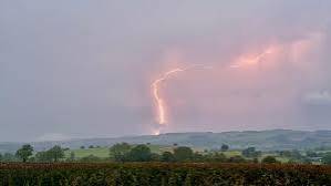
The UK’s first yellow heat-health alerts of 2025 have been issued, as the Met Office warns of incoming thunderstorms capable of producing frequent lightning, gusty winds, hail, and torrential downpours.
Some areas could experience more than half a month's worth of rain within just a few hours, increasing the risk of flash flooding from the most intense storms.
The UK Health Security Agency (UKHSA) has issued heat-health alerts covering eastern England, London, the East Midlands, and the South East. These alerts are in effect from 21:00 BST on Thursday until 08:00 on Sunday.
Temperatures in parts of eastern England are forecast to climb to 30°C (86°F), with rising heat and humidity helping to trigger thunderstorm activity.
The health alert indicates a likely increase in demand for healthcare services among vulnerable populations, particularly those over 65 or with pre-existing health conditions such as respiratory or cardiovascular diseases.
Currently, the UK lies in a meteorological battleground, with high pressure to the east and low pressure to the west. This setup is drawing humid air northward on southerly winds.

Thunderstorms are expected to begin forming on Wednesday night. The Met Office has issued a yellow weather warning for south-west England and Wales, effective from midnight until 13:00 BST on Thursday.
A separate yellow warning is in place for Northern Ireland from 06:00 to 21:00 on Thursday.
Rainfall will vary significantly across regions. Some locations may receive 10–20mm (0.4–0.8in) in just one hour, or 30–40mm (1–1.5in) in three hours, raising concerns over flash flooding.
Another round of storms is forecast to develop in the south on Friday evening, moving north across much of the UK overnight into Saturday.
A yellow thunderstorm warning has been issued for south-east England and East Anglia from 15:00 on Friday to 06:00 on Saturday.
Rainfall will once again be highly variable, with some storms dropping 30–50mm (1–2in) of rain — well above half a month’s typical total — and causing further flash flooding. Gusty winds and large hail are also possible.
Storms Driven by a Spanish Plume
These thunderstorms are linked to a Spanish Plume — a complex atmospheric setup involving layers of warm and moist air originating from Spain, France, and the Atlantic. This pattern creates an unstable atmosphere capable of producing intense storms.
Due to the volatile nature of this system, the forecast may change with short notice, so further updates to weather warnings are likely.
Heatwaves: The New Normal?
How hot is too hot? From experimental heat labs to wineries and firefighting helicopter pilots, explore how extreme heat is reshaping lives and landscapes across the UK.
No comments yet
Be the first to share your thoughts!