
Open main menu
Search
Share pictures of the theme "Home and Habitat" with the entire world and win great prizes!
Upper East Region
Article Talk
Language
Watch
Edit
Learn more
This article needs to be updated. (January 2020)
The Upper East Region is located in north Ghana[5] and is the third smallest of the 16 administrative regions in Ghana. It occupies a total land surface of 8,842 square kilometers or 2.7 per cent of the total land area of Ghana. The Upper East regional capital is Bolgatanga, sometimes referred to as Bolga. Other major towns in the region include Navrongo, Paga, Bawku and Zebilla.
Upper East Region, Dagbon
Region
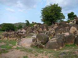
Rock formation in the Tongo Hills near Gorogo
Location of Upper East Region in Ghana
Country
Ghana
Capital
Bolgatanga
Districts
10
Government
• Regional Minister
Paulina Patience Abagaye[1]
Area[2]
• Total
8,842 km2 (3,414 sq mi)
• Rank
Ranked 9th
Population (2010 Census)[3]
• Total
1,046,545
• Rank
Ranked 9th
• Density
120/km2 (310/sq mi)
GDP (PPP)
• Year
2013
• Per capita
$5,150
GDP (Nominal)
• Year
2013
• Per capita
$2,500
Time zone
GMT
Area code(s)
039
ISO 3166 code
GH-UE
HDI (2017)
0.520[4]
low · 8th
Geography
Tourism
Demographics
Transportation
Administrative divisions
Education
Notable native citizens
References
Sources
Last edited 14 days ago by Rlink2
RELATED ARTICLES
Bolgatanga
Town in Upper East Region, Ghana
Bolgatanga Girls Senior High School
School in Bolgatanga, Ghana
Notre Dame Seminary Senior High School, Navrongo
Content is available under CC BY-SA 3.0 unless otherwise noted.
Privacy policy Terms of UseDesktop